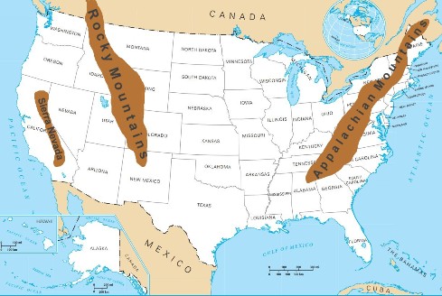
The United States of America has a lot of different kinds of landscapes, and there are more than 300 major peaks that are at least 3,000 metres high. Mountains in us map ranges shows where the main mountain ranges are and how they are spread out across the country.
In the east are the Appalachian Mountains, and in the west are the Rocky Mountains, Sierra Nevada Mountains, and Cascade Mountains. The states of Colorado, Alaska, and California are home to most of its highest peaks.
This mountains in us map ranges will help you find your favourite mountaintop and find out which state it is in. It also gives a short description and some interesting facts about each range.

The Rocky Mountains
The Rocky Mountains are a range of mountains in the western part of the U.S. They go from New Mexico in the south, through British Columbia and Alberta in Canada, and into Alaska in the United States. This is a distance of up to 3,000 miles (4,800 km).
Mount Elbert, in the state of Colorado in the Sawatch Range, is its tallest peak. In Canada, the Rocky Mountains are called the Canadian Rockies, and Mount Robson is the highest point in the range.
They are also one of the most beautiful natural wonders that show the ruggedness and independence that are important to Americans. The Rocky Mountains have been a big part of American life for hundreds of years and have helped shape the country in many ways.
| Length | 3,000 miles (4,800 km) |
| States/Provinces | British Columbia, Alberta, Washington, Idaho, Montana, Wyoming, Utah, Colorado, and New Mexico |
| Highest Peak | Mount Elbert (4,401 m/14,440 ft) |
The Appalachian Mountains
The Appalachians are the largest mountain range in eastern North America. They run along the east coast of the United States. The Appalachians start near the border between Canada and the United States in New Brunswick and Nova Scotia and go south to the northern edge of Alabama.
People have called the Appalachians “the backbone of North America” because they are so important to the geography and culture of most of the continent. Hikers, climbers, and campers have been coming to this area for years because of how beautiful it is.
When you visit this area, you can see many natural wonders, such as waterfalls, lakes, rivers, and the Appalachian Trail, as well as beautiful views. The Appalachians also have a number of amazing subranges, such as
- The Great Smoky Mountains
- Blue Ridge Mountains
- Green Mountains
- White Mountains
- Longfellow Mountains
- The Berkshires
| Length | 2,000 miles (3,200 km) |
| Provinces | Newfoundland and Labrador, Quebec, Nova Scotia, and New Brunswick |
| States | Maine, New Hampshire, Vermont, Massachusetts, Connecticut, New York, New Jersey, Pennsylvania, Maryland, Washington, D.C., Delaware, Virginia, West Virginia, Ohio, Kentucky, Tennessee, North Carolina, South Carolina, Georgia and Alabama |
| Highest Peak | Mount Mitchell (6,684 ft/2,037 m) |
The Cascade Range
The Cascade Range is a chain of mountains in US map that goes from western Washington to northern Oregon. Mount Rainier, the highest peak, is more than 14,000 feet above sea level. It is a huge system of volcanoes and volcanic peaks, with Mount St. Helens being the most famous and active one.
This range is made up of dozens of smaller volcanoes and related formations that were formed by several volcanic eruptions over the last million years. Some of these eruptions were so strong that they sent a lot of rock and lava flying into the air. Even though they are pretty to look at, it can be dangerous to hike near them.
| Length | 700 mi (1,100 km) |
| States/Provinces | British Columbia, Washington, Oregon, and California |
| Highest Peak | Mount Rainier (14,411 ft/4,392 m) |
Brooks Range
The range of Brooks It is a large area of mountains in US map, between Alaska and Canada, that rise quickly from the arctic plains around them. The mountain range is about 700 miles (1,100 km) long and goes east to west.
Mount Isto, which is the highest point, is 8,976 feet (2,736 metres) above sea level. Animals and plants like caribou, polar bears, and even musk oxen live in the range.
| Length | 700 mi (1,100 km) |
| States/Provinces | Alaska and Yukon |
| Highest Peak | Mount Isto (8,976 ft/2,736 m) |
Sierra Nevada
One of the most popular national parks in the United States is the Sierra Nevada. This range of mountains is on the border between California and Nevada. There are a lot of plants, animals, and microorganisms that live in the ecosystems of the mountain range.
The Sierra Nevada Mountains are also surrounded by beautiful landscapes and views that take your breath away. The Sierra Nevada Mountain Range is in the western part of North America. It is one of the most popular places to visit in the country.
It’s a great place to go camping, hiking, snowshoeing, backcountry skiing, and more in the great outdoors. Even though it’s not the biggest mountain range, it’s home to Yosemite, Sequoia, and Kings Canyon national parks.
| Length | 400 miles (640 km) |
| States/Provinces | California |
| Highest Peak | Mount Linn (Elevation 8,098 ft/2,468 m) |
Alaska Range
The Alaska Range is a long, thin mountains in US map that goes from northwest Canada to the southern end of the Bering Sea. It has the highest peak in North America, Denali (Mount McKinley), as well as many other well-known peaks, like Mount Foraker, Hunter, and Hayes.
Alaska has been wanted for its natural resources and beauty for hundreds of years. Many people who go to Alaska also go to the Alaska Range Mountains to see their history, wildlife, and beautiful views. There are volcanoes, ice fields, and glaciers in the range.
| Length | 400 miles (640 km) |
| States/Provinces | Alaska |
| Highest Peak | Denali (20,310 ft/6,190.5 m) |
Coast Mountains
The beautiful Coast Ranges are a group of mountains in US map that stretch from the Pacific Ocean to the Cascade, Sierra Nevada, and Klamath mountain ranges. The California Coast Ranges are a group of rough mountains that run along the coast for about 400 miles (644 km).
Peaks can be more than 8,000 feet high, and sea cliffs can drop hundreds of feet straight into the ocean, making for dramatic views. The coastal forests are lush and green, and at lower elevations, the trees are spread out. The Coast Ranges have a huge number of places for plants, animals, and people to live.
| Length | 400 miles (640 km) |
| States/Provinces | California |
| Highest Peak | Mount Linn (Elevation 8,098 ft/2,468 m) |
Adirondacks
The Adirondacks are 5,000 square miles (13,000 square kilometres) of beautiful land in upstate New York. Lake George, which is to the east of the range, can be seen in a beautiful way from the nearby mountains and hills. This amazing park, Adirondack Park, is known for its rocky terrain, unique flora, and wildlife that includes bears, moose, black bears, coyotes, and river otters.
There are also lakes in the Adirondacks, like Lake Champlain and the Great Sacandaga Lake. There are a lot of places to fish in and around these lakes, as well as places to camp and swim. This hiking trail also takes you through some of the most beautiful places in the United States.
The Adirondack Mountains rise sharply from the lakeshore. Their highest peaks are over 5,000 feet high (1,500 m). The range goes mostly north to south, and the Hudson River, which flows south, cuts it in half. Parts of Vermont and Quebec are also in this wilderness area for a large part of it.
| Area | 5,000 square miles (13,000 sq km) |
| States/Provinces | New York |
| Highest Peak | Mount Marcy (5,344 ft/1,629 m) |
Moutains of Ouachita
The Ouachita Mountains, also called the “Ouachitas,” are a range of mountains in northwest Arkansas and southeast Oklahoma. Magazine Mountain, in Mount Magazine State Park, is the tallest point at 838 metres (2,753 ft). The Ozark Plateau’s southern edge is made up in part by the Ouachita Mountains.
The Ouachita Tribe, who lived in the area before Europeans arrived, gave the mountains their name. The Ouachita Mountains go through the middle of both Arkansas and Oklahoma. With its steep cliffs, rough canyons, and waterfalls, it is a beautiful place to see.
| Length | 160 miles (260 km) |
| States/Provinces | Arkansas and Oklahoma |
| Highest Peak | Magazine Mountain (2,753 ft/838 m) |